Storm-ravaged Louisiana braces for strike from Hurricane Delta on Friday
Landfall is forecast on Friday afternoon or evening along Louisiana’s central or western coast, parts of which are still recovering from a devastating strike from Category 4 Hurricane Laura in late August.
“Delta is expected to grow in size as it approaches the northern Gulf Coast, where there is an increasing likelihood of life-threatening storm surge and dangerous hurricane-force winds beginning Friday, particularly for portions of the Louisiana coast,” the National Hurricane Center wrote Wednesday.
The Hurricane Center has issued a hurricane warning from the Texas-Louisiana border to Morgan City, La. which includes the zone where Laura made landfall.
The storm may ashore as a Category 2 in the coastal region just to the south of the area between Lafayette and Lake Charles, La., where Laura caused heavy damage and cut power in some locations for weeks.
The storm’s impact will extend far beyond where its center crosses the coast.
A storm surge warning spans from just west of the Texas-Louisiana border to Ocean Springs, Miss. The surge could cause as much as 11 feet of inundation along the coast of central Louisiana.
New Orleans may escape with only low-end tropical-storm-force winds, but any shift in the track eastward could increase storm effects there.
“NOW is the time to make sure you have a plan if you live anywhere along the northern Gulf Coast,” wrote the National Weather Service in New Orleans.
Tropical-storm-force winds could arrive along the Louisiana coastline as early as late Thursday night or Friday morning.
Delta currently
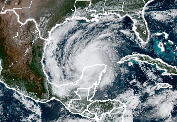
Delta was sweeping over the southern Gulf of Mexico as of 11 p.m. Wednesday, about 525 miles south-southeast of Cameron, La. The storm was heading west-northwest at 17 mph.
Moving over the warm waters of the gulf, Delta was beginning to re-strengthen, its peak winds up to 90 mph, a 5 mph increase from 5 p.m. The Hurricane Center projects Delta to regain Category 3 strength by Thursday night, with peak winds reaching 120 mph.
The type of rapid intensification that occurred while Delta was over the Caribbean, when its peak winds increased 70 mph in 24 hours, is less likely in the gulf, because ocean heat content — a measure of how much energy a hurricane can extract from surface ocean waters — is less. About a fifth to a quarter as much “fuel” is available, just enough for Delta to maintain its force while steadily strengthening.
Right as it approaches the Louisiana coast, Delta will probably weaken a bit as it encounters slightly cooler waters over the continental shelf. At the same time, hostile high-altitude winds could also work against Delta.
U.S. impacts
Delta will create multiple storm hazards along the northern Gulf Coast, including storm surge inundation, damaging winds, flash flooding and tornadoes.
The Hurricane Center is forecasting a “life-threatening” surge, or storm-driven rise in water above normally dry land at the coast, over a sprawling zone from the Texas-Louisiana border to the Alabama-Florida border. The surge will be maximized just to the east of where the center crosses the coast.
The most probable location for landfall is somewhere along the western or central Louisiana coastline between the Calcasieu and the Atchafalaya rivers or to the southwest of Lafayette.
The Hurricane Center projects the greatest surge between Pecan Island and Port Fourchon, La., where waters may rise seven to 11 feet above dry land if the maximum surge coincides with high tide. But areas as far east as Mobile Bay in Alabama could see a surge of two to four feet. The storm could also push water levels up to one to three feet above normal as far west as Texas’s Galveston Bay.
In the area devastated by a surge of up to 17 feet during Hurricane Laura, near and just to the east of Cameron, La., the Hurricane Center projects a surge of four to seven feet.
Destructive winds are also a concern.
Residents between the Rockefeller Wildlife Refuge and Morgan City, including those bordering Vermilion Bay, should prepare for 100 mph wind gusts near the immediate coastline. Farther inland, 80-to-90-mph gusts are likely in the Lake Arthur to Lafayette corridor.
The strongest winds will be found in the eyewall, or the ring of strong thunderstorms surrounding a hurricane’s eye.
A widespread four to eight inches of rainfall with localized 12-inch amounts is also likely within the swath covered by Delta’s core, which right now looks to track north through central Acadiana in Louisiana. Some flash flooding is likely.
The slug of Delta’s rainfall will move north into the Mississippi Valley on Saturday and into the Tennessee Valley and Mid-Atlantic by Sunday.
As Delta comes ashore, a few tornadoes can’t be ruled out, especially east of the center into southern Mississippi and extreme west coastal Alabama.
Effect on Mexico
Delta slammed ashore south of Cancun, Mexico, around 5:30 a.m. Wednesday with 110-mph winds.
In a stroke of luck, the storms peak winds had dropped down from 145 mph in the hours before landfall, reducing the toll on the popular resort destination. There were no immediate reports of casualties in the city or in neighboring Cozumel.
About 39,000 people in Cancún were evacuated ahead of the storm’s landfall. Many of them were American, European and Mexican tourists.
Winds of 84 mph occurred in Cancun, along with a gust to 106 mph. Puerto Morelos reported sustained winds of 54 mph and a 75-mph gust behind the center. Cozumel recorded a 64-mph wind gust.
Storms chasers Reed Timmer and Josh Morgerman, who intercepted the storm in Cancun, each reported downed trees and power lines and areas of structural damage
“Wind damage is extensive. Massive tree blowdown, lots of smashed windows & blown out signs, & some collapsed facades,” tweeted Morgerman.
Despite the considerable damage, officials were relieved it wasn’t worse.
“Fortunately, the impact was not as serious as we once expected,” said María Lezama Espinosa, Cancún’s mayor.
Delta in historical context
Delta is set to become the 10th named storm to hit U.S. soil during the 2020 hurricane season, the most ever recorded in a single year.
Storms in 2020 have been so numerous as to exhaust the National Hurricane Center’s conventional naming list for only the second time on record. Forecasters have turned to Greek letters for names; Delta became the strongest Greek-named storm observed Tuesday.
Delta’s 70-mph leap in intensity in the 24 hours between Monday morning and Tuesday morning is second fastest on record for an October hurricane in the Atlantic, trailing only Wilma in 2005. This sort of rapid intensification is expected to become more common and severe in a warming world. Rapid intensification has occurred in six Atlantic storms in 2020.
When Delta was upgraded to a hurricane Monday, it became the ninth to form in the Atlantic in 2020. “Only 3 other years in the satellite era (since 1966) have produced 9 or more Atlantic hurricanes by October 5: 1995, 2004, and 2005,” tweeted Phil Klotzbach, a hurricane researcher at Colorado State University.
Kevin Sieff and Gabriela Martínez contributed to this report from Mexico City.