Hurricane Iota explosively intensifies to Category 5 as it bears down on Nicaragua
MANAGUA, NICARAGUA — The Nicaraguan coast prepared for Hurricane Iota on Monday as it approached as a “potentially catastrophic” Category 5 hurricane making landfall Monday night, according to the National Hurricane Center in Miami.
Iota is expected to be even more devastating than Hurricane Eta, which ravaged Central America less than two weeks ago. It is the latest Category 5 hurricane to occur in the Atlantic on record. As it moved ashore south of Puerto Cabezas, its winds slackened slightly to 155 mph, making it a Category 4 landfall, though by that point its fiercest winds had already swept inland.
“I’m really sad, to be honest, because it’s not fair that after we experienced one storm, once again another threat arrives for our people,” Presly Coleman Alejandro, an activist with the Youth Indigenous Movement of La Moskitia, said in an interview. “I don’t know what we’ve done to deserve this treatment.”
Nicaraguan authorities evacuated an estimated 30,000 people during Eta, which made landfall in Puerto Cabezas on the northern Nicaraguan coast Nov. 4. Coleman Alejandro estimates that less than half were able to return to their communities to check on their homes, crops and livestock, much of which was swept away during Eta, before having to prepare for this hurricane.
The government issued a new hurricane alert to evacuate communities, and many residents are staying in churches, schools and universities to wait out the storm. Coleman Alejandro said that shelters are not well coordinated and lack some basic supplies, such as mattresses and cooking utensils.
Hurricane Iota intensified at an exceptional rate Sunday night into Monday morning.
“This is a catastrophic situation unfolding for northeastern Nicaragua with an extreme storm surge of 15-20 ft forecast along with destructive winds and potentially 30 inches of rainfall,” the National Hurricane Center wrote.
Iota is likely to make landfall very near or in the same location as Eta did. Its predecessor moved ashore with 140 mph winds and ravaged the community of Puerto Cabezas in northern Nicaragua. Iota could equal or exceed that force as it makes landfall overnight Monday into Tuesday, with social media footage showing heavy rain and gusty winds moving ashore during the day Monday.
Hurricane warnings are up for the eastern coast of Nicaragua, eastern Honduras and Providencia Island, where Iota’s worst effects are likely.
Iota is the 30th named storm of the 2020 Atlantic hurricane season, marking a record. It’s the first time on record that the Atlantic has had two major hurricanes in November. It’s also the 10th named storm of the season to rapidly intensify, a feat that atmospheric scientists link to warmer sea surface temperatures from human-caused climate change.
Overnight explosive strengthening turns Iota into a monster
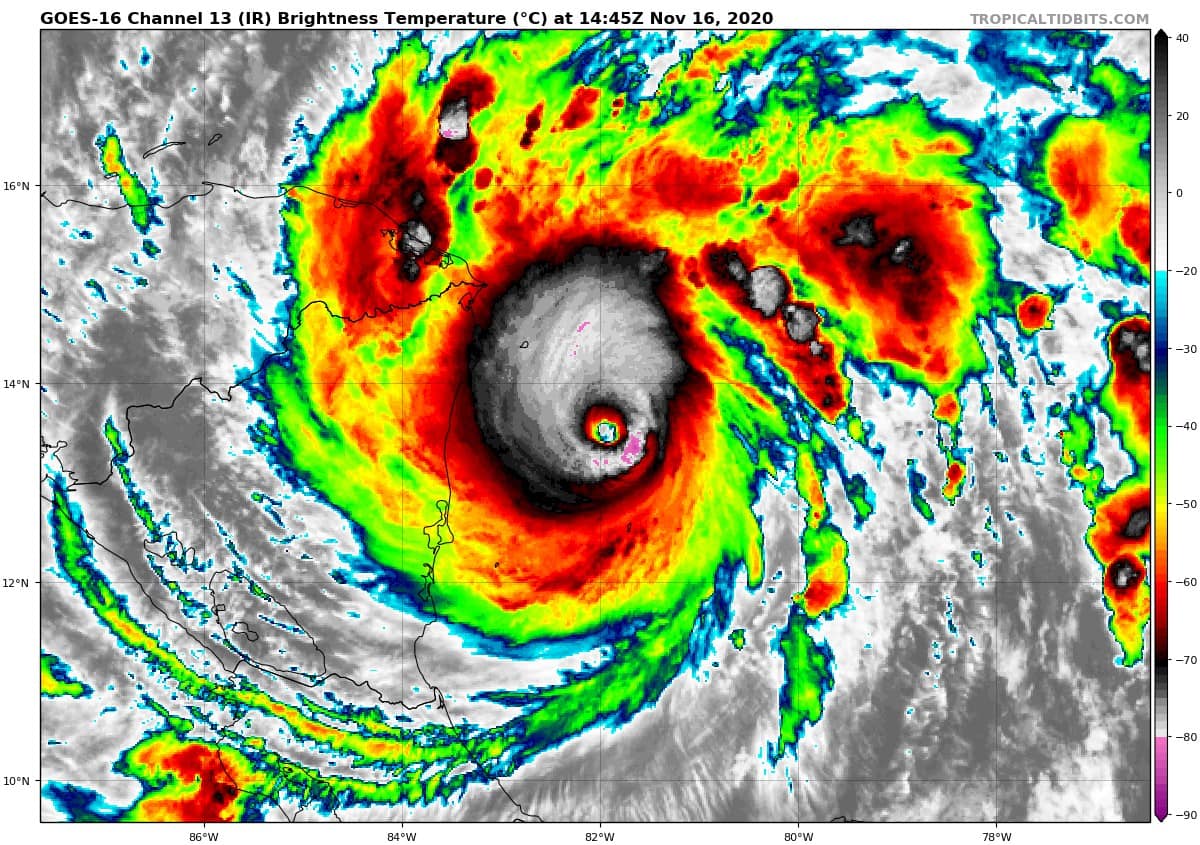
At 10 p.m., Hurricane Iota was centered about 30 miles south of Puerto Cabezas, and was churning west at 9 mph. The storm had maximum sustained winds, tightly coiled about the center, of 155 mph. The storm’s southern eyewall clipped San Andres island on Monday morning and swept inland across the Nicaraguan mainland beginning around 7:30 p.m.
Tropical storm-force winds had already spread onto land in eastern Nicaragua, including in Puerto Cabezas. The airport in Puerto Cabezas reported sustained winds of 70 mph, with a gust to 103 mph shortly before 10 p.m.
Late afternoon satellite imagery revealed Iota maintaining its fierce buzzsaw-like appearance, a maelstrom of devastating winds and lightning surrounding a razor-sharp eye.
Iota beats Laura, which struck southwest Louisiana in late August, and Eta, which made landfall in Nicaragua 12 days ago, as the strongest hurricane of the 2020 season. Activity this strong so late in the season is virtually unheard of.
Iota became a hurricane at 1 a.m. on Sunday and had lurched to Category 4 strength about 24 hours later. It has been rapidly intensifying nonstop since its early stages as a tropical storm, a rate of intensification that would be extreme even during the height of the hurricane season.
A disastrous blow to hard-hit Nicaragua and another inland flood disaster
Hurricane Iota will make landfall in Central America late Monday, probably just south of Puerto Cabezas, near Laguna de Wounta. That would place Puerto Cabezas, Haulover, and Wawa, about where Eta made landfall two weeks ago, in line for catastrophic winds and storm surge flooding in Iota’s northern eyewall. That’s the most dangerous part of the storm.
The overall environment favors maintenance of Iota’s strength until landfall. The only possible avenue for weakening would be if the system internally experiences an “eyewall replacement cycle,” which would briefly weaken winds by perhaps 15 percent.
The Hurricane Center wrote that “Iota is forecast to continue to be a catastrophic category 5 hurricane when it approaches Central America tonight.”
In preparation for the storm’s arrival, residents boarded up the windows of the houses still left standing. Fishermen’s boats were once again brought ashore. The communities affected are mainly Afro Nicaraguan and from the Miskito Indigenous community. Many communities have been without electricity since Hurricane Eta, which tore down wood-paneled homes and toppled palm trees. They are also without clean water after the storm contaminated their water sources.
Aid has been arriving throughout the week, said Coleman Alejandro, but it’s not enough. On Sunday, the Nicaraguan government, with the support of the Nicaraguan Red Cross, sent an aid caravan with food and hygiene kits to communities in the northern Caribbean coast affected by Hurricane Eta, according to a statement from the National System for the Prevention, Mitigation and Attention of Disasters (SINAPRED).
The brigade included 39 volunteers.
“Our colleagues are going to try to arrive as quickly as possible, considering the other event that is approaching us, in order to be there before any circumstance,” SINAPRED Director Guillermo González said.
“The population experiences stress at a time of crisis, especially children, women and elderly people,” he said. In a statement, Oscar Gutiérrez, president of the Nicaraguan Red Cross, said that getting clean water was the first priority. The second was psychological and social support for “people and kids who lost everything.”
An estimated 80,000 Nicaraguans could be affected by Hurricane Iota, according to the Nicaraguan government.
Across Central America, more than 3 million people were affected by Hurricane Eta, with the most damage occurring in Honduras, where extreme flooding affected more than 2 million people, according to the International Red Cross.
At least 250 people died across the region after flooding reached to the roofs and landslides buried homes with residents inside. The World Food Program estimates that millions in Central America need food assistance after Hurricane Eta in a region already suffering from the effects of climate change.
“Eta arrived at the worst moment, making life more difficult for millions of people who have been affected for years by erratic climate and recently by the socioeconomic crisis caused by COVID-19,” Miguel Barreto, World Food Program regional director for Latin America and the Caribbean, said in a statement Nov. 13. “It also worries us that rain and flooding could destroy the next harvest, which subsistence farmers depend on.”
Historical perspective
Iota is the strongest hurricane ever observed this late in the season and ranks as the second-strongest November storm on record. Iota’s peak winds leaped 40 mph in six hours Sunday night, quadrupling the criteria for hurricane rapid intensification, which is a 35 mph increase in 24 hours.
Its sudden strengthening was also reflected by a sudden drop in pressure, toppling 61 millibars in 24 hours, the fourth-fastest decline on record, trailing only hurricanes Gilbert (1988), Rita (2005) and Wilma (2005).
This kind of rapid intensification is becoming more likely because of warming ocean waters. The water temperatures east of Nicaragua, where Iota has explosively strengthened, have warmed markedly in recent decades during November and December.
Iota’s intensity and rapid strengthening have helped make the 2020 season even more exceptional, compared with past seasons:
This year marks the fifth straight with a Category 5 storm forming in the tropical Atlantic, the longest stretch on record. Iota is the seventh Category 5 storm during that span.
Matthew Cappucci and Jason Samenow reported from Washington. Andrew Freedman contributed to this report.