It’s been two weeks since the system that would eventually become catastrophic Hurricane Ian churned through the Caribbean, and now it looks like a new tropical system could be developing in its wake. Newly formed Tropical Storm Julia is bringing heavy rain and gusty winds to northern Venezuela and Colombia, and could become a hurricane as it churns toward Nicaragua this weekend.
Developing hurricane to slam Nicaragua with high winds and flooding rain
Unlike its predecessor, Julia won’t pose the threat of recurving to the north and affecting the Gulf of Mexico or Lower 48. High pressure over North America will act as a guardrail that will steer it farther west.
But damaging-to-destructive winds will buffet coastal Nicaragua over the weekend, with up to 15 inches of rain and the potential for “life-threatening” flash flooding and mudslides, according to the National Hurricane Center.
A hurricane warning is in effect for San Andres, Providencia and the Santa Catalina Islands in Colombia, with a hurricane watch in effect for coastal Nicaragua between Bluefields and the Honduras border.
In the nearer term, a tropical storm warning covers Colombia from Riohacha to the Venezuela border.
Until the start of September, tropical activity in the Atlantic was only hovering around 10 percent of what’s typical for a season to date; August was the first in 25 years to pass without a single named storm forming. Since then, Ian and Fiona both peaked at Category 4 strength, and activity has lurched to 77 percent of average.
By a metric of ACE, or Accumulated Cyclone Energy — a figure that estimates how much energy storms expend in the form of strong winds over their lifetimes — September 2022 was more active than September 2020 or 2021.
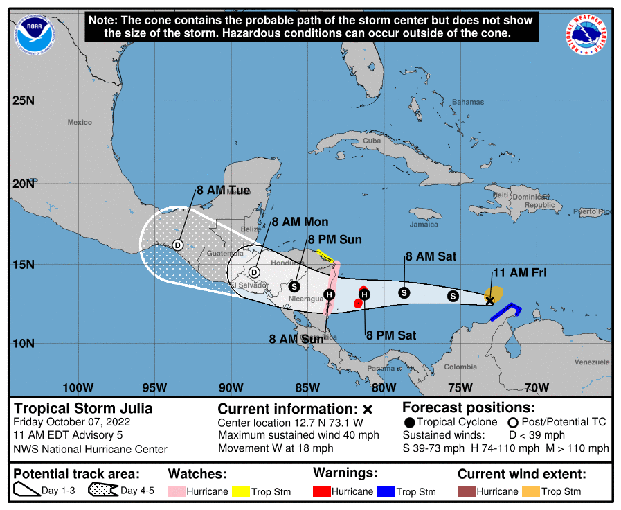
Julia was named a tropical storm as of 11 a.m. Friday. Maximum winds were estimated at 40 mph in the core. The storm was 110 miles west of the northern tip of the Guajira Peninsula and was moving west at 18 mph.
As of midmorning, the NOAA GOES East weather satellite captured a burst of convection, or shower and thunderstorm activity. That’s a sign of a strengthening system.
An Air Force Reserve Hurricane Hunter aircraft investigating the system found winds of 38 mph, 1 mph shy of tropical storm force, a few thousand feet above the ground. Considering that the mission had just started, the National Hurricane Center was confident that tropical-storm-force winds were bound to be present elsewhere inside the storm, and it was subsequently named Julia.
Julia was working to fend off shear, or a disruptive change of wind speed and/or direction with height. There are signs that shear should abate over the next 24 to 36 hours, which would allow Julia to take advantage of warm Caribbean Sea surface temperatures and intensify.
Forecast going forward
While the ocean waters are plenty toasty to support strengthening, rapid intensification, as was the case with Ian, is not anticipated.
Ian had clockwise-spinning high pressure sitting on top of it, which helped fan air away from the system at upper altitudes. That aided in Ian’s outflow; the more air a storm evacuates from above, the more its air pressure can plummet and the more it can ingest warm, humid air from below. That aids in strengthening.
For Julia, high pressure will remain banked up to the north and it probably won’t strengthen as quickly.
Moreover, Julia is drifting west more swiftly than initially forecast, limiting the window for intensification. As such, it will probably make landfall in Nicaragua by Sunday morning. By then it should be a Category 1 hurricane. That means coastal gusts could reach 85 mph. A 2- to 4-foot storm surge, or rise in ocean water above normally dry land, is also possible.
Far more concerning is the potential for torrential rains amounting to 5 to 10 inches or more in parts of Nicaragua, Guatemala, Honduras and Belize.
The storm will dissipate into a remnant low as it heads into the Pacific early next week.
Source: WP