First full 3-D digital scan of Titanic provides new details about 111-year old wreck
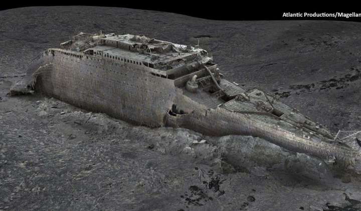
Deep-sea mapping using a pair of submersibles has produced the first full three-dimensional digital scan of the Titanic, which sank on its maiden voyage on April 15, 1912.
The scan was carried out by Magellan Ltd., a deep-sea mapping company, and Atlantic Productions, which is making a documentary about the project. Both firms announced the model Wednesday.
The famous boat, the sinking of which caused around 1,500 fatalities, rests 12,500 feet down on the Atlantic Ocean floor. The wreck was found in 1985, decades after the Titanic sank while sailing from Southampton, England, to New York City.
The cruise liner is so large that previous exploration of the site provided only snapshots, with crews unable to capture the entire scene. The boat lies in two pieces, with the bow and stern separated by around 2,600 feet.
Last summer, two submersibles 434 miles off the Canadian coast took 715,000 images, giving the Magellan-Atlantic team the wherewithal to create the 3-D digital scan. The data is 10 times larger than any previously attempted underwater 3-D model.
The scan was able to pick out the smallest details, including the serial number on a propeller. The 3-mile-wide field of debris surrounding the pieces of Titanic was found to include statues, unopened champagne and personal effects from the doomed passengers.
Researchers are racing against the clock, as microbes, water movement and general degradation wear down the wreck. Some details, like the bathtub in the quarters of Capt. Edward Smith, have already disappeared from view, according to NBC News.
Further study of the model could also corroborate or correct details about the Titanic sinking, such as how the ship collided with the iceberg.
“We don’t even know if she hit it along the starboard side, as is shown in all the movies. She might have grounded on the iceberg,” Titanic researcher Parks Stephenson told the BBC.